Welcome to Congress Park, BungalowVille

Perhaps Congress Park should be renamed BungalowVille. Sitting in the shadow of the ghastly tales of its northern neighbor, Cheesman Park, there’s not much that sticks out about Congress Park. But if you love bungalows and an occasional spark of difference in a stable and walkable neighborhood, Congress Park is for you.
Congress Park began as Prospect Park, otherwise known as Denver’s cemetery or Cemetery Hill. The rich buried their family members here, but it soon became an eyesore on this windswept hill with little access to water. In swept State Senator Henry Teller. Seeing the development opportunities of the area, the fine Senator thought it might be good to turn a neglected cemetery into a glorious park and appealed to the US Congress. Congress agreed with the Senator, demanding that the buried bodies in Prospect/Cemetery Hill get re-interned elsewhere and dictated that the city could purchase the land for $1.25 an acre. In return, the city named the park after Congress, thus, “Congress Park.” Eventually, the area to the west of the park would become Cheesman Park and the Denver Botanic Gardens.
Here are the tales of a Congress Park urban hiking adventure.
From the Turn-of-the-Century to 1950s

Making a solid rectangle shape along York/Colfax/Colorado/6th Ave, a walk through Congress Park is more about taking a left and a right when you feel like it than a particular route. Perhaps a turn-of-the-century church in the distance looks interesting, or someone’s landscaping draws your eye, but no matter which way you turn, you’re sure to see pretty much the same thing street after street. It’s the land of bungalows built as a way for folks to escape the smoggy bottoms of downtown Denver (see Union Square).
Save up to 30% on New Deals from Brands You Love on REI.com. Hurry, limited time. End dates vary.
A Grocery, A Pizza Shop, A Fine Restaurant, and a Home Goods Store

Once billed as Capitol Heights by clever developers in order to escape the macabre reputation of Cheesman Park (although it never became a depository for the graves of Cemetery Hill), Congress Park appealed historically to middle-class folks who wanted easy transit via trams and trolleys. Eventually, the trolleys went away, single car garages seeped in, and cars won out. Not much has changed in Congress Park since the mid 50s, except for perhaps a turn over of the original grocery stores in the business center.
A Few Mansions Say Hello

Denver’s largest historic district, the 7th Avenue Parkway Historic District, spans Congress Park extending all the way to the Governor’s Mansion in Capitol Hill. The city bought the parkway land in 1912, redesigned the streets, and hired an outside consultant to work with city landscaper Saco DeBoer to design the plantings. The Frederick Law Olmsted firm, designer of New York’s Central Park, was the consultant. Both DeBoer and Olmsted affected much of the landscape architecture around Denver, including many of its famous parks and landmarks. You’ll find most of Congress Park’s more elegant homes along the Parkway, decorating the street between double rows of elms, some original to the area.
Save up to 30% on New Deals from Brands You Love on REI.com. Hurry, limited time. End dates vary.
There are a few surprises in the neighborhood. Colfax Ave always morphs into something new, and an occasional larger house pops up along the Avenues. The E 7th Avenue Parkway invites walkers and runners with babies, strollers, and dogs to exercise along the larger homes of the area. And Signal Hill in Congress Park’s park, at the height of the neighborhood, used to field Denver’s 911 calls.

So if you love bungalow architecture, a stable environment, and the view of a few larger homes, take an urban amble through Congress Park. When you’re finished, you might want to visit its beautiful neighbor, the Denver Botanic Gardens, which is owned by the City of Denver. Ask them where the dead bodies are.
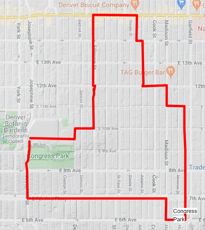
The route (click for interactive map):
 Start in the parking lot on Josephine just southeast of the Denver Botanic Gardens on the east side of the street where the closest street address is 889 Josephine. Walk east past the 911 center and the pool. You’ll come to an alley.
Go north in the alley to E 10th Ave, where you’ll go east. Take a left (north) on Fillmore Street. Pass by the block after block of bungalow homes making your way north to Colfax.
Turn east (right) on Colfax and smell the many wonderful Greek places to eat all owned by the same Pete. At Steele St take a right (south) to E 14th Ave. Take a left, then take a right on Adams St.
Go south to E 12 Ave, and take a left. Go south on Madison Street to 11th Ave where you’ll take a left.
Take a right on Monroe and walk all the way south across 7th Ave Parkway to 6th. Notice how the neighborhood homes get just a bit bigger. Take a right on 6th, then take another right on Monroe St.
Take a left on 7th Ave Parkway, enjoying a nice long amble along the Parkway, admiring the biggest houses in the neighborhood. At Josephine, take a right and return back to Signal Hill where you started.

Trackbacks/Pingbacks