
The 42-mile 9 Creeks Loop Around Denver (Segment 8)

The 9 Creeks Loop is a 42-mile hike that physically circles the city of Denver on trail. It uses a combination of 4 regional trails to lap the city. I have broken the 42 miles into 8 easy ~5 mile segment that are flat, have easy to find trailheads and trailends, and all can be walked in any direction. Transit is mostly available to the trailheads, although you may need to be a bit creative. When I walk the loop, I often will take a Lyft. You can certainly walk the segments as out-n-backs as well.
9 Creeks Loop Segment 8 Miles 35-42 The Finale!

When writing up this article, I walked the 9 Creeks Loop in a clockwise route, starting in Globeville. You can easily start it at any of the trailheads and walk in either direction. Here is my write-up of the final segment, Segment 8.
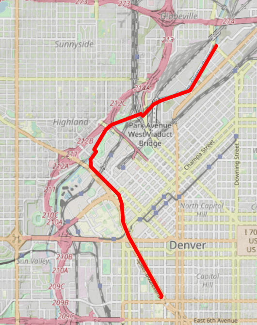
Trailhead: Sunken Gardens Park 1099 Speer Blvd., Denver, CO 80204
Trailend: Globeville Landing (corner of 38th St and Arkins Ct, Denver)
Highlights: Art along Cherry Creek, Confluence Park, Cuernavaca Park
Comments: This segment, which completes the 9 Creek Loop, takes you through a walking art gallery. When you think you’ve had your fill of artistic beauty, you round the corner at Confluence Park and see the natural beauty of Confluence Park. You’ll continue north along the Platte River, enjoying its wide views, finally reaching the end of the loop at Globeville.

The route: If you’ve been walking the 9 Creeks Loop in a clockwise route, find the trailhead at Sunken Gardens (1099 Speer Blvd) and return back to the trail by crossing over the creek and turning north on the east side of the creek which is designated for walkers.
Now that you’re back on the trail, cement walls will surround you on both sides as the trail continues next to the creek. You’ll discover one of Denver’s best kept secrets, its public art fund. This fund sets aside 1% of $1 million capital projects within the City for public art. Part of those funds go for street art. The cement walls became canvases for global street artists to share their craft. Changing frequently, you’ll see dozens of murals along the walls as you amble toward Confluence Park.

What mural is your favorite along the Cherry Creek?
The Confluence of Rivers and Ideas

At the intersection of Cherry Creek and Platte River sits Confluence Park. Overlooked by REI to the west, apartments to the Northeast, and a park to the Southeast, this mecca of activity draws water lovers, outdoor enthusiasts, and sun bathers from around the region. Kayakers, tubers, sand castle builders and coffee drinkers mingle here enjoying the exciting rapids and confluence of these two water bodies. On the cement walls bordering the water, artists have painted their best pieces.
Take a right at Platte River, picking up the ninth of the nine creeks, and enter the Platte River trail. You’ll go under 15th Street and meander through Commons Park as it links to Cuernavaca Park. These two urban parks invite all types of adventure, artwork, and invite. Get distracted and enjoy the parks or the cafes that front them, or continue down river (northward).
The Platte River Arrives

The South Platte River eventually flows to the Gulf of Mexico via the Mississippi by way of Nebraska. Its history roots in the Colorado gold rush, and it owns the birth of Denver along its banks. Like many rivers that flow through cities, it’s been through its need for respect, from a place to dump trash, chemicals and waste, to a place that residents love, fish, and boat. Known for its Brown and Rainbow Trout, the River hosts many events, people, and games throughout the year. Walking along the Platte always brings forth a variety of people and views.
The Platte River Trail, a concrete path of 8 feet wide, follows the west side of the River for a short while and then crosses over to the East. Although people still use the Platte to commute, it’s not nearly as many as the Cherry Creek Trail. The Platte is also a corridor for historical wayfarers and new wayfarers a like. Jack Kerouac used the trail to journey from the Denargo Fruit Market to downtown to meet up with his buddies Neal Cassady and Alan Ginsberg. Currently, some of Denver’s homeless and listless hang along the Platte, spending their days awaiting their next moves. Don’t let this discourage you, just be alert as you amble northward. Just smile, say hello, and continue your journey.
Have You Been to Globeville?

In about a mile, you’ll arrive at Globeville back where you started this loop if you started with Segment 1. At this point, you will have crossed over nine bodies of water–Sand Creek, High Line Canal, Westerly Creek, Toll Gate, West Toll Gate, East Toll Gate, Cherry Creek, Goldsmith Gulch, and the Platte River–and covered about 42 miles.

The Route:
Here is an interactive map of the route. You can click on it to get a close-up view.
Walking the 9 Creeks Loop and Denver By Foot
Follow us on Instagram and Facebook to keep updated on new hikes and adventures.
You can find more information about the 9 Creeks Loop here.
Thank you so much!