
Rounding the Platte River while Hiking the 9 Creeks Loop Mile 0, Segment 1 (Mile 0-5)
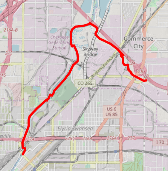
Trailhead: Globeville Landing (corner of 38th St and Arkins Ct, Denver)
Trailend: Dahlia Trailhead (4900 Sandcreek Dr S, Commerce City, CO 80022)
Highlights: Platte River, Sand Creek Confluence, Suncor
The 9 Creeks Loop is a 42-mile hike that physically circles the city of Denver on trail. It uses a combination of 4 regional trails to lap the city. I have broken the 42 miles into 8 easy ~5 mile segment that are flat, have easy to find trailheads and trailends, and all can be walked in any direction. Transit is mostly available to the trailheads, although you may need to be a bit creative. When I walk the loop, I often will take a Lyft. You can certainly walk the segments as out-n-backs as well.) Read the backstory.

The Loop travels on 4 established Denver trails, but there is no consistency in measurement on the Loop. One trail’s 5 mile marker could be the 11 mile marker of the Loop. In this narrative, I do my best to estimate which mile is which on the entire 9 Creeks Loop.
Mile 0 of the 9 Creeks is an arbitrary place. Since the 9 Creeks is a loop, it really doesn’t matter where you start. If you want to follow along in your own version of this walk, start at Globeville Landing, which I call mile 0.
9 Creeks Loop Mile 0 Starts along the Platte River

Globeville sits north of Denver along the Platte, railroad lines bisect it, and interstates 70 and 25 eventually would run through it. Only one street car stop ever existed here, so, historically, due to the limited access to safe and fluid walking areas, the workers of the Globe Smelter stayed and felt isolated from Denver. In addition, the configuration of roads and the interstate earned the area the nickname, “The Mousetrap,” due to the impossibility of navigating the ons and offs of the major thoroughfares. But funny thing is, when walking along the Platte River Trail, it’s pretty straightforward and easy to follow.
Even During the Off-Season, Livestock Visit the Place

On this route, you’ll pass through Globeville into Denver’s water treatment areas (both historic and current), past its historic Riverfront Cemetery, cross over the confluence of the Platte River and then turn onto the Sand Creek into Commerce City. You’ll get a glimpse at large petroleum and gas processing plants and start to understand the backstory to how Denver drinks water and transits. Finally, you’ll exit this segment at the Dahlia Trailhead.

Start Your 42-Mile Hike at Globeville Landing
Park at Globeville Landing and start the 9 Creeks Loop by going clockwise, or to the right. You’ll be one the 8-ft wide concrete Platte River Trail. In no time, you’ll arrive at the Northside Park (now called Carpio Sanguinette Park) or what used to be the old Denver sewage plant, which closed in the 80s. After becoming destitute and an eyesore, the City with the help of the National Guard cleaned the brownfield up and turned it into a park. Take a moment to read the interpretation of the park and use the restrooms.

Up ahead, you’ll cross the Burlington Ditch. Created in the 1880s by a group of enterprisers who wanted to sell water rights and construction bonds, the Burlington Ditch services the City of Denver’s new wastewater plant and nearby farmers, eventually dumping into Barr Lake.
You’ll soon pass Riverside Cemetery. With some of Denver’s elite buried there, it continues to offer space now and competes with the Fairmount Cemetery to the south.
Sign Up For Free Shipping and Exclusive Member Offers at Columbia.com.

You may smell the Wastewater Plant about 1/2 mile before approaching it, so it’s best to do this segment when it’s cooler and the wind blows to the north or west. Pass the brown-colored buildings and holding tanks as you make your way to the bridge crossing the river at the confluence with the Sand Creek Trail. If you continue north on the Platte River Trail, you’ll end up in Thornton. Rather, cross the river and end up on the Sand Creek Trail.

Looking over the edge of the bridge, gawk at the 4-6 foot long catfish in the effluent. Immediately after exiting the bridge, the Trail turns southeast, and almost immediately again, you’ll cross the Burlington Ditch again, approaching the Suncor petroleum plant.

The Sand Creek’s elevation drops to the edge of the Sand Creek, and large marshlands house wonderful birding along the Trail. Continue along, going under caged areas that protect you from falling debris from train tracks.
Soon, you’ll pass under Vasquez, arriving at the Dahlia Trailhead, which is the end of the route for this segment. Segment 2 picks up here at the Dahlia Trailhead.
Crazy comfortable. Crazy colorful. Bombas are the MVPs of every sock drawer with their ultra-soft fabrics and thoughtful, comfortable design. Shop now and use code BOMBAS20 for 20% off your first purchase.

Walking the 9 Creeks Loop and Denver By Foot
You can find more information about the 9 Creeks Loop here.
Follow us on Instagram and Facebook to keep updated on new hikes and adventures. Thank you so much!
Trackbacks/Pingbacks